

Knockmealdown [Cnoc Mhaoldomhnaigh]
Good walks are even better shared.
S0508 : Knockmealdown summit
Richard Webb Photo source
Overview
Knockmealdown is the 792.4 m highpoint of County Waterford and the highest summit in the Knockmealdown Mountains on the Tipperary–Waterford border. Its trig pillar stands above steep northern slopes, with rugged approaches from the Vee and the road junction below its southwest flank.
Knockmealdown / Cnoc Mhaoldomhnaigh
Knockmealdown rises to 792.4 m on the Tipperary–Waterford border. It is Waterford’s county highpoint and the highest summit in the Knockmealdown Mountains. A trig pillar marks the top, with very steep ground immediately to the north and northeast. In clear weather the outlook includes the Galtees, Slievenamon, the Comeraghs and the southern lowlands towards the coast.
Routes
These are open-mountain walks with steep and rough ground. The car park above Bay Lough, the Vee hairpin and the lower Glentanagree Bridge parking are different places; choose the start for the route you intend to follow.
Bay Lough car park via Sugarloaf, out and back
Start and finish at the R668 car park above Bay Lough, around S030100. Cross the road carefully and climb the steep, stony path beside the low wall to Sugarloaf Hill. Follow the ridge southeast down to the broad col, then continue beside the boundary wall up towards Knockmealdown’s trig pillar. Keep back from the very steep ground on the north and northeast sides of the summit. Return along the same ridge, reascend Sugarloaf and descend the original stony path to the road and car park. This route does not descend to Bay Lough itself. The ridge is exposed to wind and cloud, and the descent needs secure footing.
Glentanagree Bridge direct ascent and return
Start and finish at the roadside parking by Glentanagree Bridge near the R668/R669 junction, around S040078. Take the hillward rough approach at the road fork and climb the southwest slopes of Knockmealdown. Lower ground is heathery, wet and locally pathless; higher up it becomes steeper and rockier. Continue to the trig pillar at 792.4 m, staying back from the steep north and northeast edge. Retrace the same southwest approach to the road fork and bridge parking. Allow about 2 hours 30 minutes for this shorter return. Locate the descent carefully in cloud; the ridge towards Sugarloaf is a different route.
Knockmealdown–Sugarloaf horseshoe
From the roadside parking by Glentanagree Bridge at the R668/R669 junction, around S040078, ascend Knockmealdown’s heathery southwest slopes to the summit trig pillar. Descend northwest beside the boundary wall to the col, then climb to Sugarloaf Hill’s summit cairns. Turn towards the west/southwest side and descend the steep, stony path beside the wall to the R668 car park above Bay Lough. Complete the circuit by walking south along the R668 to the original bridge parking. The published horseshoe is about 10 km with 600 m of ascent; allow 3 hours 30 minutes to 4 hours. The road carries traffic and has bends: assess visibility and passing space before committing to this return. Use the direct out-and-back instead if road conditions are unsuitable. No Bay Lough shore detour or Knockmoylan extension is included.
Terrain and safety
The ridge paths are stony and can be loose underfoot. Heather, wet ground and indistinct tracks make the direct southwest approach more demanding than its short length might suggest. Carry a map and compass, know how to use them and leave enough daylight for the return. Discovery sheet 74 covers the summit. Take warm and waterproof clothing, food, water and a headtorch; be ready to turn back if cloud, wind or footing make the route unsafe.
Keep back from the summit’s steep northern edge. Do not improvise a descent towards the corries or lake. The road-return horseshoe needs a separate judgement about traffic and visibility. Respect landowner signs, leave gates as found and keep farm and emergency access clear. Sheep graze the hills; Mountaineering Ireland advises leaving dogs at home on livestock uplands.
Geology and neighbouring hills
Knockmealdown is formed from Devonian Old Red Sandstone. The local Knockmealdown Sandstone Formation is described as medium-grained pink-purple sandstone. Regional folding during the Variscan mountain-building episode created the east–west structure, with erosion leaving resistant sandstone ridges above lower valleys.
Sugarloaf Hill is a separate 662.7 m summit on the ridge route. Other nearby tops include Knockshane, also called Knockmoylan, at 767.1 m; Knocknagnauv at 655.1 m; and Knocknafallia at 666.5 m. Adding them changes the distance, climbing and return plan.
Getting there
The Sugarloaf ridge route starts at the R668 car park above Bay Lough, around S030100. The direct southwest route and horseshoe start by Glentanagree Bridge at the R668/R669 junction, around S040078. These are different starting points. Park fully off the carriageway, follow current signs and keep gates and access clear. If a parking area is full or restricted, use another authorised place rather than roadside overspill.
Bus Éireann route 245 serves Clogheen between Cork, Fermoy, Mitchelstown and Clonmel. It does not provide the mountain-pass trailhead connection described here; arrange onward and return transport to the chosen start. Check the day and direction at https://www.buseireann.ie/routes-and-timetables/245 before travelling.
Bring food and drinking water for the mountain. Clogheen, Lismore and Cappoquin are the nearby places to plan supplies and services. Keep the roadside parking and hill free of litter.
Name and history
Cnoc Mhaoldomhnaigh means “hill of Maoldomhnach”, a personal name meaning “devotee of the church”. The name is associated with the surnames Muldowney and Moloney.
Historical accounts record the burial of Henry Eeles, a writer on electricity and Lismore land agent, on Knockmealdown in October 1781. An 1841 map places the grave near the summit trig pillar, but stories that he was buried with animals or a gun are disputed. Grubb’s Monument near the Vee is a separate grave, that of Samuel Grubb, who died in 1921.
Explore routes near Knockmealdown [Cnoc Mhaoldomhnaigh]
Walks starting near this hill. Open a route to check its map, distance and full itinerary.
Route planning notes
These notes describe possible approaches. Check a route's map and access information when planning your walk.
Bay Lough car park via Sugarloaf, returning the same way
Start and finish at the R668 car park above Bay Lough, around S030100. Cross the road carefully and climb the steep, stony path beside the low wall to Sugarloaf Hill. Follow the ridge southeast down to the broad col, then continue beside the boundary wall up towards Knockmealdown’s trig pillar. Keep back from the very steep ground on the north and northeast sides of the summit. Return along the same ridge, reascend Sugarloaf and descend the original stony path to the road and car park. This route does not descend to Bay Lough itself. The ridge is exposed to wind and cloud, and the descent needs secure footing.
Glentanagree Bridge direct ascent and return
Start and finish at the roadside parking by Glentanagree Bridge near the R668/R669 junction, around S040078. Take the hillward rough approach at the road fork and climb the southwest slopes of Knockmealdown. Lower ground is heathery, wet and locally pathless; higher up it becomes steeper and rockier. Continue to the trig pillar at 792.4 m, staying back from the steep north and northeast edge. Retrace the same southwest approach to the road fork and bridge parking. Allow about 2 hours 30 minutes for this shorter return. Locate the descent carefully in cloud; the ridge towards Sugarloaf is a different route.
Glentanagree Bridge–Knockmealdown–Sugarloaf horseshoe
From the roadside parking by Glentanagree Bridge at the R668/R669 junction, around S040078, ascend Knockmealdown’s heathery southwest slopes to the summit trig pillar. Descend northwest beside the boundary wall to the col, then climb to Sugarloaf Hill’s summit cairns. Turn towards the west/southwest side and descend the steep, stony path beside the wall to the R668 car park above Bay Lough. Complete the circuit by walking south along the R668 to the original bridge parking. The published horseshoe is about 10 km with 600 m of ascent; allow 3 hours 30 minutes to 4 hours. The road carries traffic and has bends: assess visibility and passing space before committing to this return. Use the direct out-and-back instead if road conditions are unsuitable. No Bay Lough shore detour or Knockmoylan extension is included.
Make a day of it, together
Find someone to share the walk with, or organise a day out along a route you like.
Photo Gallery
View all Photo could not load
S0508 : Knockmealdown summit
Richard Webb
 Photo could not load
S0508 : Summit Picture
kevin higgins
 Photo could not load
S0508 : Earth wall towards Knockmealdown
Bryan Conlon
 Photo could not load
S0508 : Summit Pillar
kevin higgins
 Photo could not load
S0508 : Pillar and Plaque
kevin higgins
 Photo could not load
S0508 : Summit of Knockmealdown
Colin Park
 Photo could not load
S0508 : Knockmealdown Mountain
kevin higgins
Hill facts and local notes
Classifications
Elevation
792m
2,600 ft
Prominence
678m
Coordinates
52.2279, -7.9159
S057084
OS Map
74
At the Summit
A trig pillar marks the 792.4 m summit at Irish Grid S057084. The ground drops very steeply to the north and northeast; keep back from the edge, especially in cloud or strong wind.
Terrain & Geology
Knockmealdown is formed from Devonian Old Red Sandstone. The local Knockmealdown Sandstone Formation is described as medium-grained pink-purple sandstone. Regional folding during the Variscan mountain-building episode created the east–west structure, with erosion leaving resistant sandstone ridges above lower valleys.
Views & Scenery
In clear weather the summit looks towards the Galtee Mountains, Slievenamon and the Comeraghs, with views south across the surrounding lowlands towards the coast.
History & Heritage
Name Origin
Cnoc Mhaoldomhnaigh means “hill of Maoldomhnach”, a personal name meaning “devotee of the church”. The name is associated with the surnames Muldowney and Moloney.
Historical Significance
Historical accounts record the burial of Henry Eeles, a writer on electricity and Lismore land agent, on Knockmealdown in October 1781. An 1841 map places the grave near the summit trig pillar, but stories that he was buried with animals or a gun are disputed. Grubb’s Monument near the Vee is a separate grave, that of Samuel Grubb, who died in 1921.
Getting There & Facilities
Parking
The Sugarloaf ridge route starts at the R668 car park above Bay Lough, around S030100. The direct southwest route and horseshoe start by Glentanagree Bridge at the R668/R669 junction, around S040078. These are different starting points. Park fully off the carriageway, follow current signs and keep gates and access clear. If a parking area is full or restricted, use another authorised place rather than roadside overspill.
Public Transport
Bus Éireann route 245 serves Clogheen between Cork, Fermoy, Mitchelstown and Clonmel. It does not provide the mountain-pass trailhead connection described here; arrange onward and return transport to the chosen start. Check the day and direction at https://www.buseireann.ie/routes-and-timetables/245 before travelling.
Nearby Facilities
Bring food and drinking water for the mountain. Clogheen, Lismore and Cappoquin are the nearby places to plan supplies and services. Keep the roadside parking and hill free of litter.
Safety Information
Known Hazards
- Very steep ground lies immediately north and northeast of the summit. Keep back from the edge in mist or strong wind.
- The climb and descent on Sugarloaf have steep, loose and stony sections. The southwest approach crosses heather, wet ground and indistinct tracks.
- Cloud can obscure the ridge and the correct southwest descent. Carry a map and compass and know how to use them; a wall or phone alone is not enough.
- The horseshoe ends with walking beside traffic on the R668. Assess bends, visibility and passing space; choose a return without this road section if conditions are unsuitable.
- Sheep graze the hills. Respect current landowner signs, leave gates as found and keep farm and emergency access clear. Mountaineering Ireland advises leaving dogs at home on livestock uplands.
General Safety Tips
- Check weather conditions before setting out
- Carry appropriate clothing and equipment
- Let someone know your planned route
- Take a map, compass, and GPS device
- Carry emergency supplies: food, water, first aid kit, torch
Hills
Some common questions about the hills answered
Are there group walks up Knockmealdown [Cnoc Mhaoldomhnaigh]?
Many walkers use Walkmates to join or organise walks with others. You can check for group walks around Knockmealdown [Cnoc Mhaoldomhnaigh] through the maps
Are there other walkers around Knockmealdown [Cnoc Mhaoldomhnaigh]?
Activity varies by location and time, but Walkmates lets you see whether others have shared walks or shown interest in this area. Find other people through the walking friends search walking friends for Knockmealdown [Cnoc Mhaoldomhnaigh] search or of course create your own walk for Knockmealdown [Cnoc Mhaoldomhnaigh]
Can I organise a walk to Knockmealdown [Cnoc Mhaoldomhnaigh]?
Yes. If there aren’t any walks listed already, you can create a walk and make it available for others to join.
If you're signed up to Walkmates, you can create a walk to Knockmealdown [Cnoc Mhaoldomhnaigh].
How do I find a walk up this hill?
There are often multiple ways to walk this hill, depending on experience and route preference. Walkmates helps you explore walks and routes that others have shared.
Can I suggest a new route up Knockmealdown [Cnoc Mhaoldomhnaigh]?
Yes. You can suggest or create routes to share with others. Walkmates focuses on the social side of walking, so routes are used to help people organise walks and explore areas together, rather than as detailed navigation tools or route libraries.
Other uses really appreciate knowledgeable walkers sharing their routes. Share your favourite route to Knockmealdown [Cnoc Mhaoldomhnaigh] here
The is an error or something incorrect about this hill. How do I let you know?
We always strive to keep the information on Walkmates as accurate as possible. If you find an error, please let us know through the contact form and we'll aim to correct it as quickly as possible
Community Discussion
Comments
Location
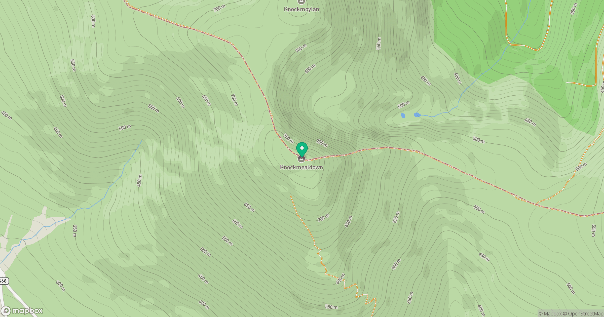
Grid reference: S057084
View on OpenStreetMapOpens a map in a new tab, centred on the hill.
No comments yet. Be the first.